THE LIVING ARCHIVE
THE IT FILE
No file sits alone
REDISTRICTING · VOTING POWER · REPRESENTATION · QUIET GEOMETRY
How Gerrymandering Works
How district lines can reshape political power without changing a single vote.
QUESTIONS IN THE FILE
Start with the line that moved the room.
WORD IN THE FILE
Gerry-mander
The term appeared in 1812 after a Massachusetts state-senate district was compared to a salamander.
FOLLOW THE ORIGIN →HOW THE LINE MOVES
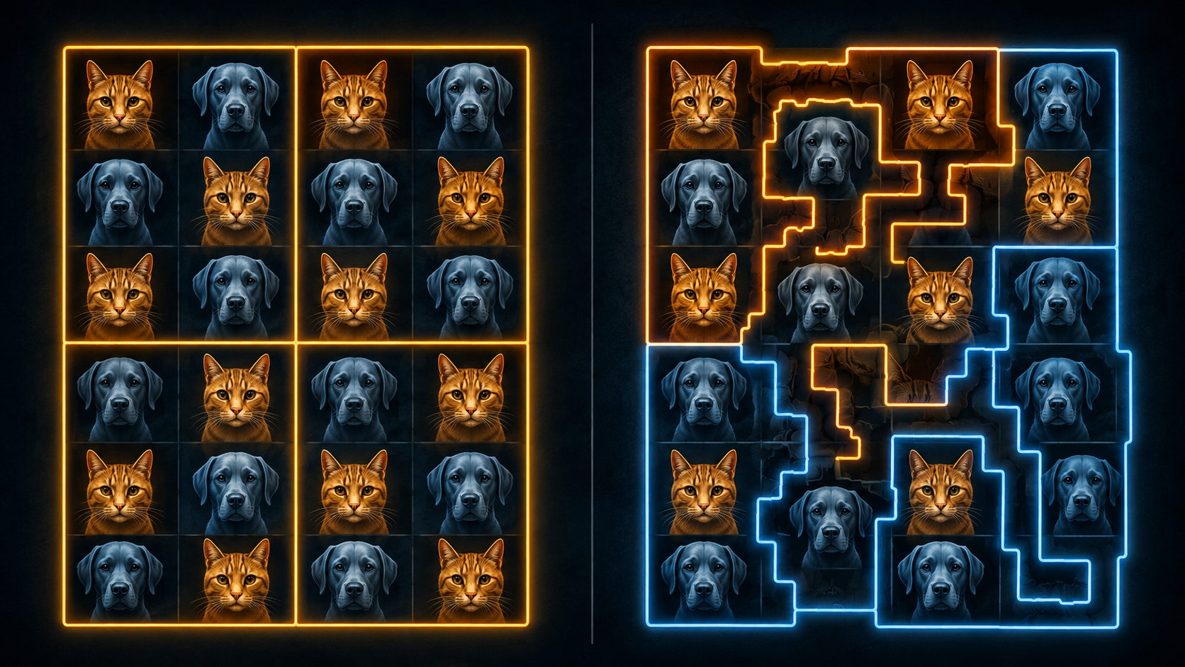
Packing + Cracking
Packing concentrates voters into fewer districts. Cracking splits a community across several districts.
CURRENT MAP ROOM
Recent Lines to Follow
QUICK ANSWER
What Is Gerrymandering?
Gerrymandering is the drawing of political district boundaries to shape electoral outcomes. The voters may remain in the same homes. Their ballots may still be counted. But the lines around them can change which votes are grouped together and which communities have enough combined voting power to elect a representative of their choice.
Redistricting itself is normal. Districts must be updated as populations change. The concern begins when boundaries are drawn to dilute voting power, protect incumbents, or engineer a partisan advantage.
The quiet part is what makes the pattern easy to miss: the vote does not disappear. It gets rearranged.
THE MECHANISM
Same Neighborhood. Different Frame.
A map can look technical while doing something deeply human. Boundaries decide which neighbors count together, which communities are split apart, and which groups are concentrated into a smaller number of seats.
The two best-known techniques are simple enough to explain without a garden.
METHOD 01
Packing
Many voters from one group are concentrated into a small number of districts. The group may win those seats by enormous margins while having less influence elsewhere.
METHOD 02
Cracking
A community is split across several districts so its voters do not form a strong enough bloc in any one of them.
METHOD 03
Incumbent Protection
Lines can be drawn to make a sitting representative safer, place rivals in the same district, or shift a political opponent into less favorable territory.
METHOD 04
Mid-Decade Redrawing
Most redistricting follows the census. But some states redraw maps between censuses after court rulings, political openings, or changes in strategy.
IMPORTANT DISTINCTION
Not Every Map Fight Is the Same
Partisan gerrymandering is the drawing of district lines to favor a political party.
Racial vote dilution concerns district lines or voting practices that weaken the electoral opportunity of voters because of race, color, or membership in certain language-minority groups.
The two can overlap because racial identity and party preference may correlate in particular places. But they are not interchangeable terms, and the legal rules are not identical. The U.S. Department of Justice provides a Section 2 redistricting reference.
THE HUMAN SIDE
Representation Changes the Room
Maps can look like paperwork. Representation does not.
When a community can elect a representative responsive to its concerns, different experiences enter committee rooms. Different harms are spoken into the record. Different neighborhoods stop appearing only as statistics.
When a community is packed, cracked, delayed, or diluted, the consequence is not only party math. It is also a question of which lived experiences become official concerns and which remain background noise.
PATTERN UNDER REVIEW
Quiet Geometry
The houses stay where they are. The street names do not change. The voters still arrive at the ballot box.
But a line moves, and the political weight of the neighborhood can move with it.
A technical process can rearrange a human voice.
The quietest part of the map may be the part doing the most work.
No verdict entered. Start with the line. Then follow the consequence.
FIELD NOTES
The Line Is Quiet. The Consequence Is Not.
Gerrymandering is easy to underestimate because it rarely looks dramatic. It arrives as a map, a filing, a deadline, a court order, a legislative session, or a technical explanation of why one boundary now belongs somewhere else.
Some maps are redrawn because populations change. Some are redrawn because courts require corrections. Some are redrawn because the people holding the pencil see an opportunity.
The lines alone do not answer every question. But they tell the reader where to begin looking.
Who was grouped together? Who was split apart? What changed after the boundary moved? Which communities gained a stronger voice, and which became easier to overlook?
The map does not have to erase a voter.
Sometimes it only has to rearrange the room.
OPEN THE LONG MAP
THE LONG MAP
A Timeline of Moving Lines
The cases and legal standards change. The recurring question does not: who gains a voice when the boundary moves, and who loses one without leaving home?
The Name Appears
The term, first written as “Gerry-mander,” appears after a Massachusetts state-senate district signed into law by Governor Elbridge Gerry is compared to a salamander.
Rights on Paper
The Fourteenth and Fifteenth Amendments establish constitutional protections after the Civil War. Voting rights expand in law while barriers continue in practice.
The Voting Rights Act
The Voting Rights Act becomes a major federal tool against racial discrimination in voting. Section 2 applies nationwide.
Shelby County v. Holder
The Supreme Court invalidates the coverage formula used to determine which jurisdictions were subject to federal preclearance before changing voting rules.
Rucho v. Common Cause
The Supreme Court holds that partisan-gerrymandering claims present political questions beyond the reach of federal courts.
Allen v. Milligan
The Supreme Court upholds a lower-court ruling involving Alabama and Section 2, leaving in place a requirement for a second district where Black voters could elect a candidate of choice.
Louisiana v. Callais
The Supreme Court changes the legal landscape again. States move quickly to revisit congressional maps.
OPEN THE CURRENT MAP ROOM
RECENT MAP ROOM
What Changed in 2026?
These examples are not presented as identical. They show why the lines, the timing, and the legal standard all matter.
LOUISIANA
A Majority-Black District Removed
After the Supreme Court’s April 2026 decision in Louisiana v. Callais, Louisiana approved a new congressional map dismantling a Democratic-held majority-Black seat.
READ THE REPORT →TENNESSEE
Memphis Split Three Ways
Tennessee approved a new congressional map dismantling a majority-Black U.S. House district centered on Memphis. Shelby County was divided among three Republican-leaning districts.
READ THE REPORT →ALABAMA
The Court Fight Continued
In June 2026, the Supreme Court allowed Alabama to use a congressional map reducing the number of districts where Black voters make up a majority or near-majority from two to one while litigation continued.
READ THE REPORT →NEW YORK
The Countermove Began
In June 2026, New York Democrats advanced a proposed constitutional amendment that could make it easier for lawmakers to redraw congressional maps for 2028. The proposal still faces additional steps, including voter approval.
READ THE REPORT →OPEN THE SCOREBOARD QUESTION
THE SCOREBOARD QUESTION
Which Side Uses Gerrymandering More?
Both major parties have used partisan redistricting when they controlled the mapmaking process. The advantage changes by decade, state, court ruling, and the rules governing who draws the maps.
For the maps used in the 2024 U.S. House elections, a Brennan Center analysis found a net 16 fewer Biden districts than under its non-gerrymandered comparison maps. The center concluded that the overall bias in that cycle’s maps strongly favored Republicans, driven largely by aggressive line-drawing in Republican strongholds in the South and Midwest.
In the 2026 mid-decade fight, Reuters reported that Republican-led redistricting efforts had secured or were likely to secure the larger gains, potentially adding up to ten U.S. House seats. Democratic efforts included a California map and a newer New York proposal, but the map room remained active and the final effects unsettled.
OPEN QUESTIONS UNDER REVIEW
QUESTIONS UNDER REVIEW
Questions to Ask When the Map Changes
No verdict entered. Start with the line, then follow the consequences.
Authority
Who drew the map, and who had the final authority to approve it?
Timing
Was the map redrawn after a census, a court ruling, or a political opportunity?
Packing
Which communities were concentrated into fewer districts?
Cracking
Which communities were split apart across multiple districts?
Stated Purpose
Is the stated goal compliance, racial fairness, partisan advantage, incumbent protection, or some combination?
Effect
Did the number of voters change, or only the lines around them?
Gain
Who gains a seat after the map moves?
Loss
Who loses a voice without physically going anywhere?
OPEN THE SOURCE TRAIL
SOURCE TRAIL
Start with the Public Record
Maps invite conclusions. The source trail keeps the questions anchored.
Editorial note: This article distinguishes ordinary redistricting, partisan gerrymandering, and racial vote dilution. Current examples are included to show how the legal landscape is changing, not to claim that every map dispute is identical or that every redrawn district is unlawful.
BROWSE CONNECTED FILES
CONNECTED FILES
Follow Another Line
Different rooms. Recurring questions. No file sits alone.